“Featured Image” 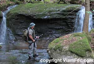 On this scout I parked my truck along Route 2 in Shelburne NH and bushwhacked through jungle-like forest up Josh Brook on the slopes of Middle Moriah Mountain (elevation 3755 feet).
There is a small turn-off where Josh Brook crosses the Route 2 highway, which is a major east-west truck route between Maine, northern New Hampshire, northern Vermont and into Canada. Following the brook upstream from this parking area, the Portland, Maine to Montreal, Canada natural gas pipeline also crosses east-west after a short walk through hemlock forest.
As you can see in the pictures, the Great North Woods has just about completely leafed out over the course of the last week or so, creating a very lush jungle that will last until the Fall season.
Continuing up Josh Brook the land quickly becomes steeper. As is the nature of this area, steep slopes with thin soils are often stripped by rushing streams down to bedrock, creating many fine cascades, waterfalls, and deep pools.
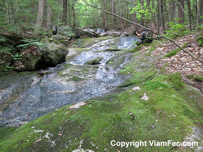
During periods of heavy rains or snow melt these small brooks often become raging torrents of surprising power.
Over the course of many thousands of years the brooks in the White Mountains area have often carved deep gulleys that are relatively shaded. Trees such as hemlock will tend to take over whereas the surrounding areas will tend to be composed largely of northern hardwoods. As you gain altitude spruce-fir forest tends to gradually take over, which eventually turns to alpine tundra above about 4800 feet altitude.
“Tends to” is an important caveat – in the mountains of the Great North Woods, nothing is permanently written in stone and nothing can be assumed, as we shall soon see towards the end of this Scout.
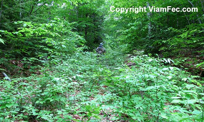
Especially in hardwood sections, the forest can probably best be described as “jungle”, and is sometimes almost impenetrable due to a labyrinth of thickly grown shrubs, saplings, and blown down trees. Because of this, it pays to have experience not only in bushwhacking but also local knowledge on a very close level in order to best negotiate the forest.
Utilize Knowledge of Local History
So you never thought you would use that history you learned while wasting the golden days of your youth in government schools? That may be so, but the kind of history I will teach you today can serve you well. Very well indeed if your aim is to penetrate the jungles of the Great North Woods while staying unseen and alive.
Over the last 130 years loggers have pushed small roads into most forest lands containing merchantable timber, up to perhaps an elevation of 3000 feet or so. This required the construction of skid roads, some quite spectacular as they made their way past all obstacles in these rugged mountains.
In the olden days, horses were used to skid logs out, so the old roads from the 1800’s and early 1900’s are often narrow and not anywhere near so graded as more modern roads. Still, such as road can serve the mountain Scout very well.
These old roads (known as “tote roads”) often follow the course of streams up into the valleys – usually narrow, rocky, and much overgrown. Often it is easier (but not always!) to walk along the remains of the road instead of having to select your own way through the jungle. What’s more, the loggers chose logical routes up into the mountains, so much of the guesswork as to which side of the stream you should be on for most efficient travel has been done for you.
For example, traveling up one side of a stream may lead to a ledge area too steep to traverse without a laborious climb around it, while the other side of the stream the old-time loggers may have discovered or created a way that skirts this obstruction.
While one such obstruction in the course of the day may not be so bad, imagine having to make five or ten exhausting detours while climbing steeply through dense underbrush. Very inefficient to be sure.
Before traveling very far up or down a stream, a woods wise Scout can first inspect both sides of a stream in order to locate a possible old logging road, which then may be a good choice to use.
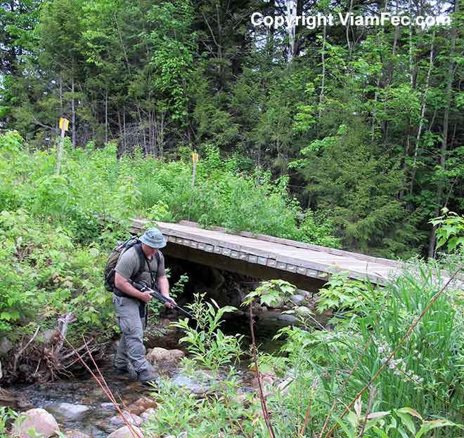
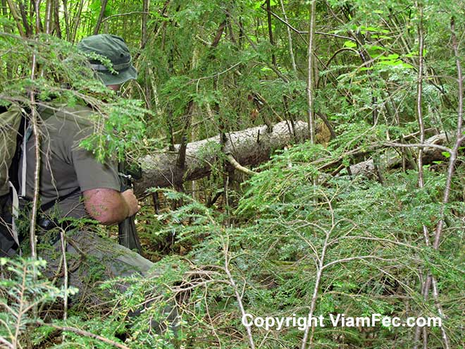
In the above picture I have discovered just such a road along Josh Brook on todays Scout. The old road has been re-used by modern loggers perhaps within the last decade or so. While a thick crop of young hardwood trees and shrubs has begun to grow, the going was easier than pushing through the larger forest growth on the opposite side of Josh Brook.
Another advantage of utilizing an old-time tote road for travel is that you can devote more of your attention resources to the area around you, rather than having to siphon off a significant part of your mindset attending to where you are going. This can be a great aid to observation – which could very well help keep you alive.
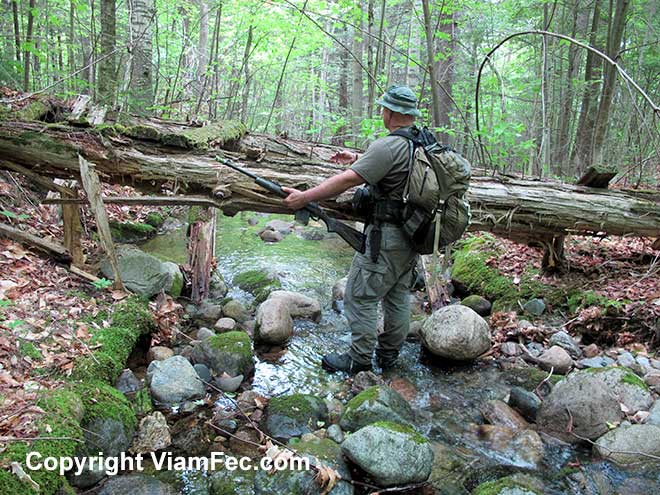
Note how quickly a person merges into the green foliage; in much of the Great North Woods a clear line of fire even just 50 yards can be rare. This is where a powerful Scout Rifle chambered in .308 can come in handy. More on that in future Viam Fec blog posts.
Use Property Lines to Map Your Position
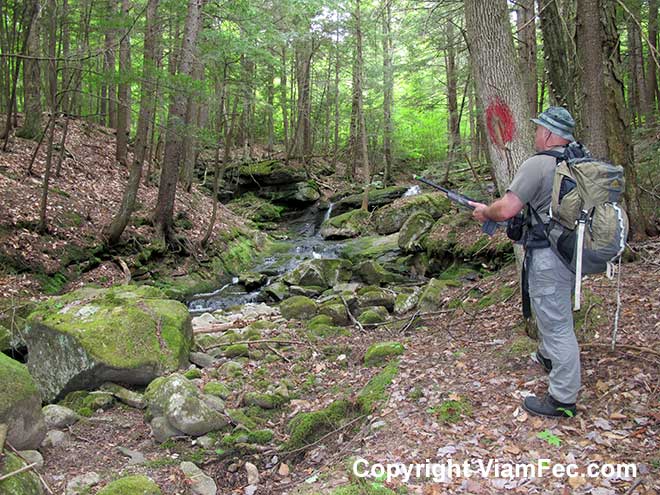
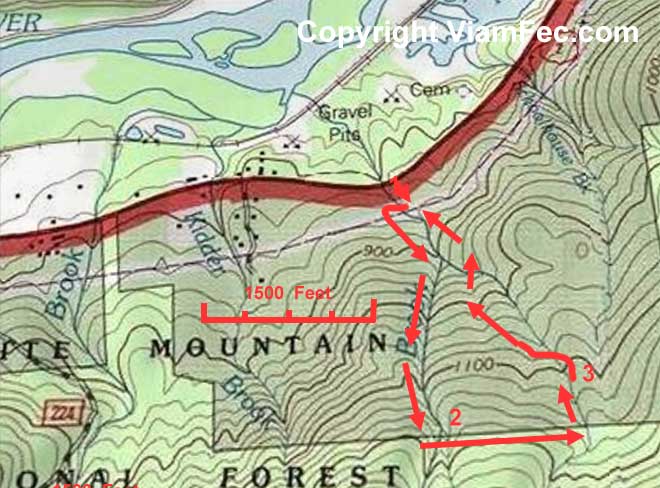
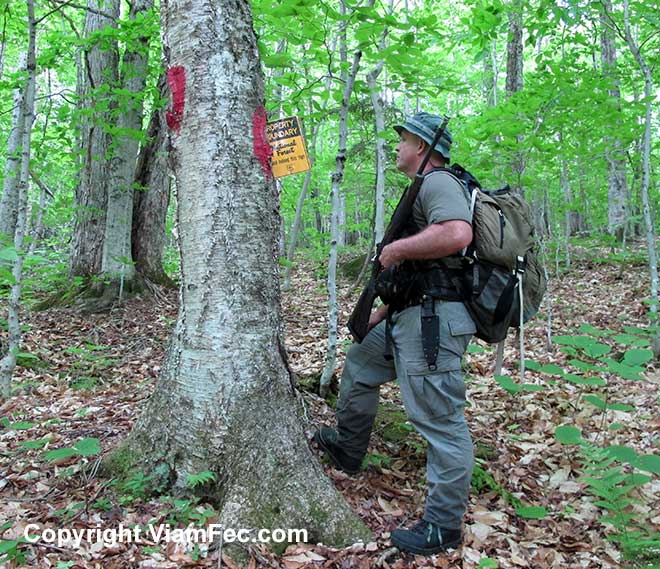
About 3/5 ths of a mile up Josh Brook I cut the White Mountains National Forest boundary line. These boundaries are always blazed into trees along the entire line using an axe and painted a specific color of red. This red paint we called “Forest Service red” back in my years as a land surveyor in the Great North Woods of New Hampshire and Maine.
Observe that by looking at the topographic map and knowing you are traveling along an easily recognized landmark such as Josh Brook, it is trivial to determine your position along the White Mountain National Forest boundary line since that will be where the brook crosses it.
However there are some caveats when using the landmark intersect method when determining your position on a map that need mentioning:
- The map is not the territory. The boundary line and/or the brook may be depicted incorrectly on the map or the map may be out of date in regards to boundary lines which can change over time.
- The blaze line as laid out by the land surveyors could be, though not likely, placed there in error.
- I have known land surveyors to use paint they were provided by the government for the marking of national forest boundaries to mark boundaries on private lands. After all, the paint was free so the surveyors use it. Just because a blaze line through the forest is painted US Forest Service red that does not necessarily mean it is a national forest boundary.
- You may actually be near a different landmark than you assume. For example, perhaps you are one brook to the left or right of the brook you think you are on, or are on a different branch of the brook having missed where the split occurred as you walked through the jungle.
Do your due diligence, check and re-check what you think may be the facts. Be open to new interpretations of the evidence you discover.
Boundary Line Falls
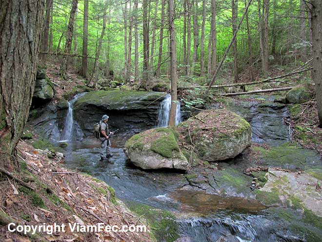
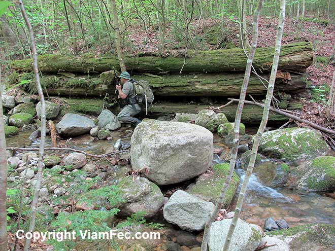
Just a stonethrow upstream from the Josh Brook / National Forest boundary line intersection is a beautiful double waterfall that invited exploration. At the base of the falls is a large boulder which leans against the ledge, creating a small cave through which you can crawl to other side.
I christened these falls and a second set of falls located behind me in this photo “Boundary Line Falls” as they do not have a name on any map I have seen.
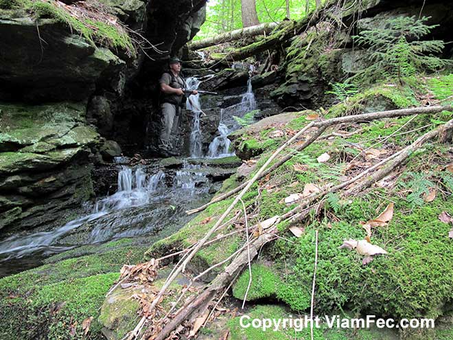
Just to the east of these falls is another falls from a small tributary that flows into Josh Brook. This falls has an interesting cave feature cut deep into the ledge.
Analyze Every Scrap of Evidence
Continuing upstream one hundred yards or so, I came upon this old logging road bridge abutment made of large logs. From the rotting appearance of these logs and new growth of trees sprouting from the road, I estimate it was last used in the 1980s. The discovery of a glass beer bottle and a glass soda bottle with faded wrappers shows this was likely last used before such beverages were typically bottled in plastic containers as they are now.
How can I use this information? Well, judging from the amount of rot on the bridge abutment logs and the presence of discarded glass bottles instead of plastic, I know the logging road was used some decades ago. It will likely be well overgrown for much of its length. Valuable information indeed when you are traveling on foot through a jungle.
Again, knowledge of history – in this case the history of glass vs plastics use over the last several decades can be a valuable aid in determining how to scout an area.
This logging road appears to parallel the National Forest Boundary, which makes sense if it was built in order to log National Forest land.
Looking at the map, it might be a reasonable guess that this logging road could be followed west along the boundary line and thence downhill to what appears to be government property access to Route 2 where the logs could be transported out by truck.
Again, you can see how using a map and knowledge of local history can give you an edge in determining your surroundings and how to best use them to advantage without ever having actually been there. Of course, everything is an educated guess and that has to be taken into consideration during any planning.
I clambered up the stream bank in order to view the condition of the road. In this case the logging road, at least here, is nearly impenetrable with young growth and blown down trees.
From the old bridge abutment I decided to backtrack down the brook to the National Forest boundary line, follow the line of tree blazes and red paint to the east branch of Josh Brook as shown on the map, and thence downstream back to the truck.
To A Future Forest Explorer
Along the way I found a National Forest Boundary line sign laying on the forest floor. I stuck a corner of the sharp sign into a blaze on this yellow birch tree. Years from now someone will come by here and find the sign deeply embedded into the birch as the tree grows larger and maybe have a chuckle. That’s one way to attach a sign to a tree.
I like sending messages into the future, especially messages that give someone a lift however comical. Such messages are everywhere in the Great North Woods if you are open to receiving them. There is many a standup comic in the human race.
Note the two blazes, opposite each other on this tree. This indicates the land surveyors believe the boundary line goes right through the center of the tree.
Unexpected Human Habitation
Continuing the scout east along the boundary line, I eventually cut the east branch of Josh Brook as depicted on the map, and began scouting downstream toward the truck. A short distance down the brook, I came upon something that startled me:
A water line!
A gravity-fed waterline made of plastic piping with a filter on the end. Currently in disuse, this end of the pipe had been pushed a short distance downstream by the force of water when the brook level was higher.
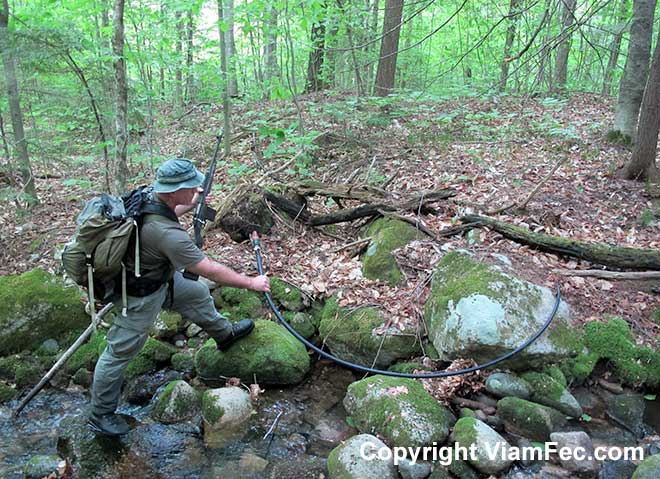
A waterline placed in Josh Brook could only mean one thing: there is, or was, a reasonably permanent human dwelling just downstream of my position.
But where?
There is no building indicated on the topographic map. However, as we know, the map is not the territory. Also, there very well could be hunting, poaching, or snowmobiling cabins in the area that are usually only used during certain seasons. Or perhaps there has been new housing constructed since the topographic map was published.
The map is not the territory.
The map is not the Territory.
The map is not the territory.
Got it?
Reserve Immediate Judgement – Always Be Open to New Facts and Surprises
In the jungle-like Great North Woods, sight distances can be exceedingly short – sometimes only yards. While out scouting it is very easy to accidentally find yourself in someones back yard. Worse, being attacked by an angry dog. Worse still by an angry land owner. And worse of all by armed humans for whatever reason.
One clue as to the position of the human structure that the waterline feeds, whatever it is, is that the water pipe is located on the east side of the brook running downhill.
Another clue as to the nature of the potential human structure in the area is the waterline itself. A permanent home or development would likely have a well or be connected to a town water supply. Water taken directly from a brook is not ideal, as it has to be treated for various disease causing organisms. In addition, during times of high water the waterline may not function and the water may become murky with mud and forest debris.
Curious, I cautiously followed the plastic pipe for a about 50-feet and found these old metal gas cans. Nowadays, due to more government regulations of the type that include fines and time in a cage if you do not obey, gas cans are made of plastic, pretty much suck and are probably more dangerous to use than the old metal cans.
Be that as it may, cans such as these could come in handy in some circumstances.
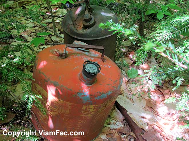
Amongst the old gas cans were piles of cinder block bricks, bits of an old wood stove, and charred lumber. The entire camp area completely overgrown with young trees and shrubs, indicating the remains of an old camp that had burned, likely from the 1980’s if I were to guess.
Nearby, an old handmade snowmobile bridge crossed the brook, giving a good indication of at least one use for this camp.
A knee jerk conclusion would be that the answer to the mystery water pipe is solved by the discovery of a ruined camp. Since the camp has obviously been in disuse for many years it is likely nobody is in the immediate area unless they are a rare bushwhacker such as myself.
Never come to knee jerk conclusions when on a Scout.
As I investigated the old bridge, a sudden shock went through me as my eye caught the tiniest glimpse of bright blue color 75-yards ahead through the thick foliage, covering what appeared to be a shed.
A good possibility a common blue tarp. Then, the distinct smell of cinnamon, like cinnamon flavored gum. Then a human figure walking past the blue tarp (or whatever it was). While I could not see the entire body of the person, swinging arms are sure indication of this species of critter.
Now this is a close call and highlights exactly what I wrote earlier in this article, how it is very easy to virtually walk right into an encampment before you even have a clue that it is there. Maybe the encampment of someone you do not want to meet face to face. The result could be disastrous.
Carefully I walked west directly away from the blue tarp area. Every so often looking back to be sure I wasn’t exposing myself to easy view through the random forest sight openings between the thick growth of trees and leaves. Each yard further away I got, the less chance I would be detected by line of sight. However, walking through thick forest with noisy dry leaves and breaking sticks on the forest floor produces a fair amount of noise.
Wildlife Can Give Away Your Position
In addition, a pesky woods hawk decided to start screeching at roughly ten second intervals. I was likely near its nest and this is what hawks do when potential predators, such as myself, are lurking about.
I thought about the person I saw beside the blue tarp and wondered how aware they were; would the alarm cry of a hawk interest them to pursue further investigation? Or would they, as most people, not even perceive it as they go about their personal business?
As for myself I am pretty much attuned to natural sounds such as that made by an upset hawk in the forest, and likely would not have missed it were the tables turned.
The Mark of Free Men is Everywhere
As I skulked away, I came upon the mark of Free Men – soda cans used as target practice. I would like to avoid being target practice myself.
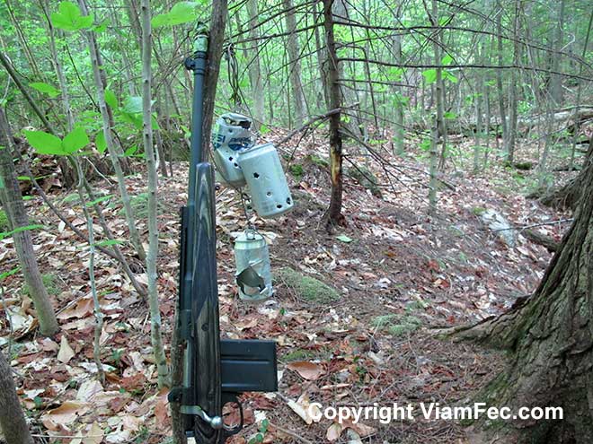
Every boy I have known in the Great North Woods either owns a firearm (often several) or knows how to shoot one. Just the way it is, like people in the city know how to use subways or hail a taxi. So it goes without saying that most adults own firearms too, and often of larger calibers.
Here we have unquestionable evidence that firearms are used by locals in the area. We also now know they practice using firearms, and we also know something of the caliber from the size of the holes in the cans.
Wire had been used to suspend the cans from a large tree. This tree had grown into the wire, so that the wire was essentially choking the tree and indicating a year or two had passed since the target practicing was done here. I untwisted the wire to release the tree, creating a loud popping noise as the wire loosened under the intense pressure.
My good deed for the day.
But enough of that, let’s beat a hasty retreat.
Morphing Into Something Else
Camouflage involves more than just clothing and actions that blend into the natural environment. You can also blend into the environment of human expectations.
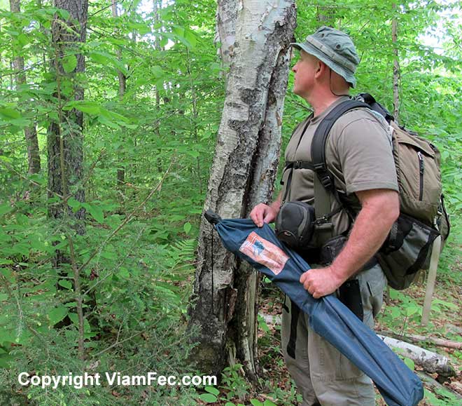
Since now I knew for certain I could not trust the map for recent housing developments as I made my way down the mountain, I placed my Scout Rifle in its beach chair bag. With camera and camera tripod, I am just a guy enjoying the great outdoors while bird or moose watching.
The walk downstream back to the truck was uneventful. I came upon no additional human habitations. I also discovered another small, very old tote-road along the east bank of the main stream near Route 2 which I followed out. The area here is largely hemlock of intermediate size and in some places interlocking dead branches made travel along the abandoned road difficult.
Re-crossing the Portland to Montreal pipeline, I was struck by the intensity of the sun as I emerged into the open from the thick jungle cover.
Conditions:
- Temperature 65 to 80 degrees F
- Sunny
- Thick Jungle Cover
Human Contact:
- Unexpected habitation
- Brief glimpse of a human through thick forest growth
Animal Contact:
- Woods hawk gives away my position
Area Covered:
- Between 1 and two miles on the north slope of Middle Moriah Mountain in Shelburne NH
Key Takeaways:
- The map is not the territory.
- You can find your position on a map using two intersecting lines such as a brook and a property line.
- Wildlife can give away your position
- Be attuned to wildlife behavior, animals act in certain ways for a reason.
- It is easy to accidently walk right into an encampment.
- Clues can be found in an amazing variety of objects.
- Know the local history and relate it to what you find on the ground.
- Never jump to conclusions about the evidence at hand
- Locals utilize the land in many ways and can catch you off guard if you are unaware.