 On this Scout I decided to climb the northwestern flank of Mount Surprise to an undetermined point and then cross over the western side of the mountain.
From here I would cut across the well-maintained Carter-Moriah hiking trail on my way downhill into the Peabody River valley and thence back to my truck.
As always, I met with unexpected adventures.
No Groomed Trails on This Scout
Don’t let the relatively short distances of these scouts fool you. The White Mountains are rugged, thickly overgrown jungles chock full of ledges, rocks, blown down trees, thick entangled shrubs, insect pests, and innumerable obstacles that only a bushwhacker in the field can understand fully.
I estimate that bushwhacking a given distance requires about 5 to 7 times the effort of covering the same distance of a maintained hiking trail.
Not only are the innumerable obstacles physically challenging but also mentally demanding, due to the fact you have to keep your wits about you in order to avoid becoming injured while trying to choose the most efficient pathways through the thick jungle and maintaining your desired course.
On many occasions when I take a companion with me on a bushwhack, they become injured in one way or another. A sprained ankle, a stick in the eye, a branch whiplashed into a face – and underscores the fact that through some 50-years of living and working in the forest I know more about woodcraft and jungle travel than I realize I know.
Safe, successful foot travel through the jungle is indeed a skill that I have learned through countless thousands of hours of actual hands-on experience.
The Map Is Not The Territory
Once again I parked the truck at the beginning of Bangor Street in Gorham and walked across the Portland Maine to Montreal Canada natural gas pipeline.
To the right is a small brook that has no name as far as I know. Interestingly, the USGS topgraphic maps are in error as to where this brook flows. The maps show the brook coming down Mount Surprise past the south end of Bangor Street and draining into the Peabody River. In fact, as the brook approaches Bangor Street it swings to the northeast and roughly parrallels the entire length of the street, crosses route 2, and drains into the Androscoggin River nearly a mile from where the topo map shows.
Again, don’t be fooled: The Map Is Not The Territory.
Logging Paths Are Used By Locals
After crossing the pipeline I crossed said brook and headed up Mount Surprise along an old partly overgrown skidder path that was created by loggers during early 1980’s. Within a short time I came across a fresh ATV track that uses this skidder path as an easy way through the forest.
Judging by the still wet track, a puddle of water the mud in which had time to settle after being disturbed, and spider webs across the trail, the last ATV had passed through here the day before.
Because the jungles of the Great North Woods are so thick and difficult to penetrate, the locals often utilize paths that were cut by logging operations. These are most often skidder trails used when logs and trees are moved – skidded – to collection areas where they are processed before trucking.
All Terrain Vehicles (ATV’s) are the favorite mode of transportaion by the locals, with snowmobiles during the winter months when there is heavy snow cover. Because the local inhabitants continue to travel the ways opened up by loggers, some of these paths remain relatively free of undergrowth since it does not have a chance to grow before it is repeated run over by wheels.
I enjoy following ATV tracks since they often lead to interesting artifacts, hunting campsites, tree stands, and other human constructions. In this I was not disappointed.
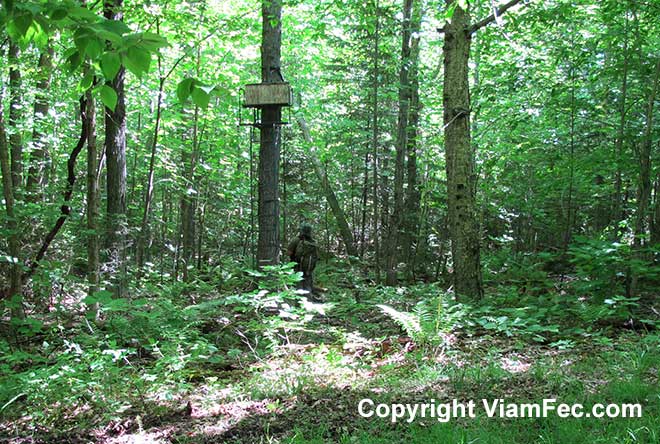
I came upon this tree stand overlooking the skidder trail and a very small opening. Nearby was a bottle of Doe Estrous, a potion used to lure in bucks during the Fall deer hunting season. Also found was a practice arrow with broken fletching, giving a clue as to sort of techniques and weapons these deer hunters use.
The jungle of the Great North Woods is littered with tree stands installed by hunters, emphasizing the need to carefully observe the forest canopy while scouting. This wildlife often fail to do, which is the reason why hunting from tree stands can be so effective.
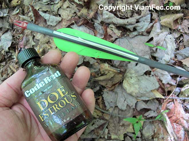
Following my practice of leaving human artifacts just as I found them, I set the empty doe estrous bottle and broken arrow on a stump and continued scouting my way up the mountain.
Animal Track Highway
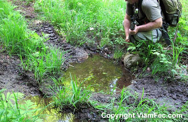
Beyond the tree stand the skidder trail became much steeper, rockier, and wetter. The recent ATV activity had disturbed the soil and vegetation, causing it to be even muddier as I scouted along. This mud created an excellent medium for the recording of wildlife tracks.
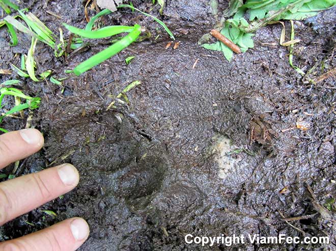
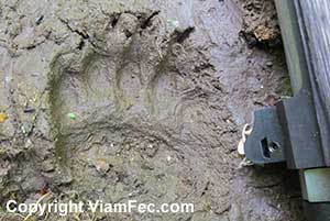
It turns out this skidder trail is something of a major wildlife highway. The fresh tracks of deer, moose, bear, and bobcat were plain to see in the rich dark mud.
The moose tracks were especially fresh: green ferns had been knocked over by a moose so recently that the ferns had not had a chance to whither, which meant the moose was likely lurking about nearby. Because moose are of a dark color that closely matches common forest shades, it is easy to accidentally find yourself standing virtually right next to a moose as sometimes they do not amble off on the approach of a human but rather stoically and silently stand their ground.
You do not want to get on the wrong side of a 1200-pound moose.

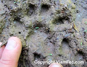
Along with the wild animal tracks were human boot footprints of about size 8 mens, which would likely indicate either a young teenage boy or perhaps those of a woman.
The human footprints were visible only in a few places, seeming to indicate where an ATV rider put his or her foot down onto the ground while adjusting the ATV in the pathway.
Note how the black bear footprints resemble those of a human, with 5-toes but more robust and squat in shape.
The bobcat tracks show four toes and no claw marks.
A Quick Note on Animal “Fear Factors”
While I always keep a sharp eye out for moose, the evidence of very recent moose activity heightened my sensitivity to the possibility of meeting up with one or more of these magnificent but potentially dangerous creatures.
And for good reason.
If asked what animal they most fear when in these mountains, probably most people would say “black bears”. However, in my experience and observation black bears are so far down the list as to be of little consideration.
By far, the most dangerous animals of all is the human animal.
Next in line in the Great North Woods is the moose, which is probably ten times more dangerous than the next in line, the black bear.
Black bears come in third, though this animal may be roughly tied with the whitetail deer in order of “dangerousness”.
Last of all that deserves much if any consideration would the the eastern coyote.

I would take a face off with a black bear instead of a moose any day. But the most dangerous animal of all is man. That will the topic of a another discussion.
Many less experienced people would scoff at these rankings, but I stand firm based on many years of experience and observation.
GPS Is Problematic in the Jungle
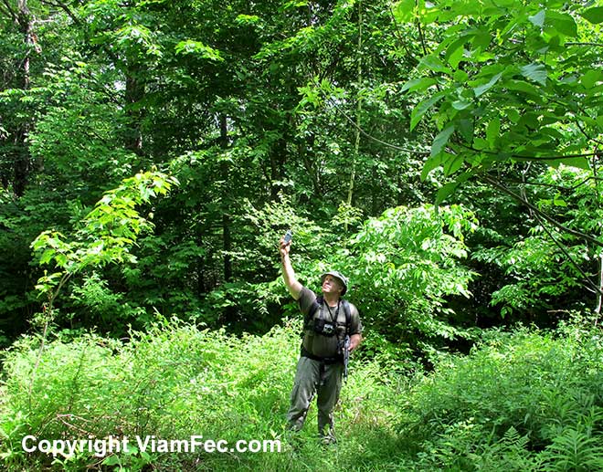
In order to better map out my locations along this scout, I often attempted to obtain the coordinates of my position. About half the attempts were “no-dice”. A GPS reading requires at least three satellites to be in line-of-sight in order to triangulate a position. In the jungle of the Great North Woods achieving at least 3 GPS satellites is often problematic.
Sometimes by moving around a bit, stooping low to the ground or raising the GPS unit above your head you can find that spot where, through the myriad leafy openings in the forest canopy, three or more satellites can be locked on to. Sometimes just a few inches in any direction can make all the difference.
Continuing up the mountain, it became quite rocky and very steep. Evidence showed where the ATV was turned around and driven back down the mountain. The skidder trail became fainter with each passing yard the vegetation thicker. This makes sense, since when the logging operation was being done here, the skidder traveled this path fewer times as it brought logs down the mountain.
As I came near the crest of the ridge I intersected a fine skidder trail that ran east-west. I followed this several hundred yards west to where I suddenly smelled what seemed to be cucumbers. This I knew to be one of the frequent large open patches of ferns which dot the mountainside at this elevation.
From the fern patch I turned uphill, crested the ridge, and soon cut the Carter-Moriah hiking trail.
From the trail I plunged back into the forest and worked my way down the mountain into the Peabody River valley. At first the way was through open hemlock forest, then steeply downhill through dense young forest growth that hindered progress considerably, being difficult to squeeze through a continuous wall of saplings.
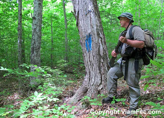
Eventually the forest opened up into old growth, where I found a blue blaze line trending north-south. I cut this line as I continue on my way downhill (west).
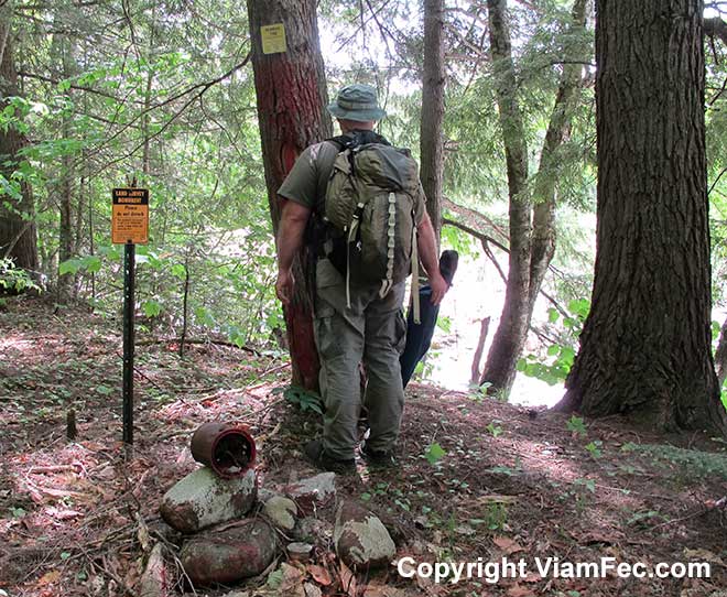
A way later I came upon the common red blazed National Forest boundary line and followed this down to the Peabody River where there is a property line monument.
When I was a land surveyor during the 1980’s and 1990’s I set many of these monuments for the government. They always have a pile of red painted rocks, an aluminum disk stamped with information and set into the ground, and at least three bearing trees recorded.
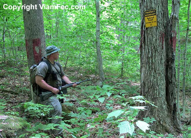
Here you will also find the obligatory empty, rusting bucket that held the red marking paint. Painting blazed trees for miles down the line is a messy business and the surveyors will usually drop off their empty paint buckets rather than carry them out of the forest.
When I was a land surveyor running property boundaries, I spent many an evening at home washing red paint off every part of my body. A set of outdoor clothing was sacrificed to the painting gods, used whenever there was a line to blaze and paint.
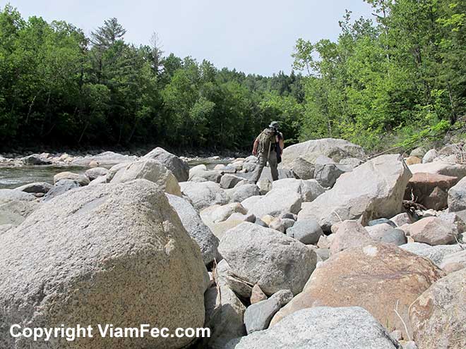
Emerging out onto the Peabody River, the bright sun was blinding after spending the day in the womb of the dark jungle. I headed downstream, hopping from rock to rock while carrying a full load on my back plus a rifle.
I’ve spent many a day rock hopping on the boulders of the Peabody River. This is a great place to grow up, the river draining the Great Gulf Wilderness and Mount Washington, home of the world’s worst weather. In fact, rock hopping is a skill set in and of itself – and one of the best physical exercises you can do since it involves strength, balance, and mental agility in quickly finding good routes and adjusting to unexpected occurrences such as loose rocks and pivot points.
I followed the river back down toward Bangor Street and my truck, stopping for a swim near what the locals call “!st Hole”. The cold clear water just what was needed after miles of sweaty bushwhacking in the Great North Woods.
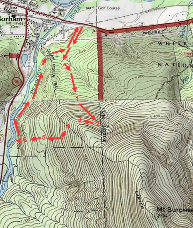
Above is a rough map of the scout with numbers depicting approximate locations of the following:
- Numerous animal tracks in mud and a tree stand.
- Open skidder trail trending east-west.
- Fern garden opening.
- Cutting the Carter-Moriah Trail.
- Blue blaze line found.
- Red blaze line found, which I followed to the Peabody River.
A couple things to note:
- I took a GPS reading on the red blaze line. The position I recorded does not match the position of the National Forest Boundary line as depicted on the map.
- What does the blue blaze line donote?
I should have taken a GPS reading on the National Forest boundary monument located next to the Peabody River as another check about where the boundary line really is in relation to the map.
Again, the map is not the territory and what I found in the field as far as these boundary lines (and the brook) do not match that which is on the USGS topographic map.
Conditions:
- Temperature 60 to 80 degrees F
- Sunny
- Thick jungle cover, open sunny rocks
Human Contact
- ATV tracks
- Human footprints
- Hunting Stand
Animal Contact
- Moose tracks
- Bobcat tracks
- Whitetail Deer tracks
- Black Bear and Bear Cub tracks
Area Covered
- Lower northeast quadrant of Mount Surprise in in the towns of Gorham and Shelburne
- Lower Peabody River
Key Takeaways
- The map is not the territory
- GPS in thick jungle is problematic
- Scan the forest canopy as much as the ground