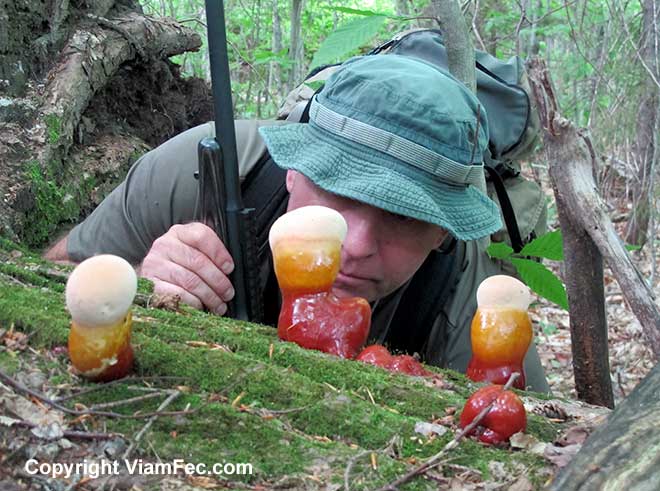
Interesting fungi growing on a tree that has been toppled by wind.Today on a more ambitious scout I climbed two mountains. The first Mount Evans (elevation 1443 feet) and the second an Unnamed Peak (elevation 2572 Feet) both to the north of Middle Moriah Mountain (elevation 3755 feet) in the Carter-Moriah Mountain Range.
The last day of Spring, it was a cool and windy slog through a myriad of obstacles, alot of compass work, boundary line hoping, and guesswork navigational estimation.
The Demise of the Armchair Generals
The mountains and jungle forests of the Great Northwoods is a scouts paradise. It can chew up a man within just one day unless he is woods savvy and in excellent physical and mental shape.
Sure, the trails maintained by the US Forest Service and Appalachian Mountain Club are relatively easy to hike, but step off from them and you are plunged into a very different sort of adventure.
As is usual in these mountains, the way is steep, rocky, and blocked by thick vegetation and blown down trees. I estimate a bushwhack is typically about 5 to 6 times more difficult compared to hiking along an open well-maintained trail. Because one cannot walk a straight line through the thick jungle, what with all the twists and turns and backtracks in order to get from point a to point b, this days scout was maybe about six or seven miles long nominally – equivalent to thirty to thirty-five miles on a nicely maintained mountain trail.
To cover this distance required a slog of just over 12-hours, or a little over 1/2-mile per hour. The underbrush ripped one leg of my bdu’s to shreds.
Your typical armchair general or the guy who relies chiefly on mobile transportation, drinks alot of beer, possibly smokes, and doesn’t get much real physical (or mental) exercise – he just isn’t going to have the stamina to do it.
Not only is bushwhacking much more physically demanding, it also requires a high level of awareness as you must use all available resources and forest savvy to keep on track and get where you want to go without becoming lost or injured.
Don’t let the armchair generals fool you – the map is NOT the territory and the mountainous forest will eat you up if you are not woods-wise and in excellent shape.
Pre-Dawn Assault
At this latitude (nearly 45-degrees North) it starts becoming light enough to see at about 4:15 am this time of year. It pays to arise before that, in order to catch the world unawares. I woke up at 3:30 AM, fixed breakfast, got my gear in order and hit the road.
Destination: Shelburne New Hampshire and the Rattle River trail head. This is where the Appalachian Trail intersects with Route 2.
Climbing Mount Evans
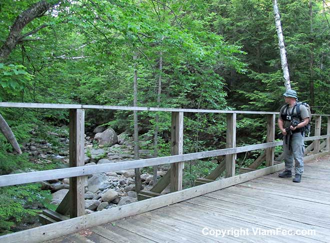
Near the trail head I hopped rocks across the Rattle River and headed up through the forest jungle toward the summit of Mount Evans. Within a short way I came upon this snowmobile bridge where a snow machine trail crosses Rattle River on its way towards Gorham NH. It is labeled “1” on the map.
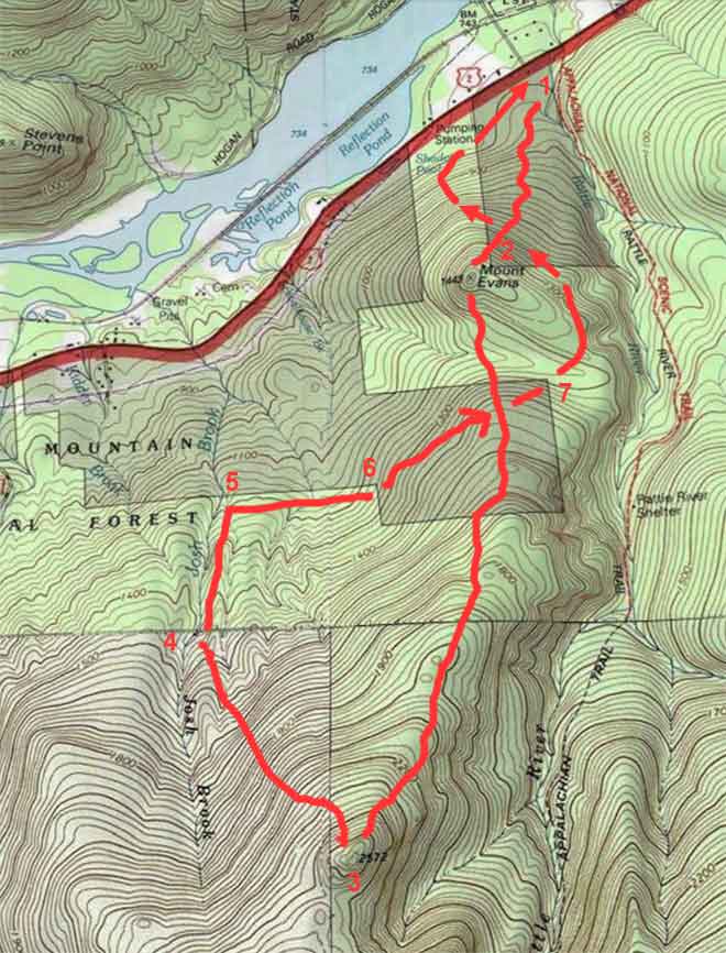
Todays Scout: 1) snowmobile bridge 2) Mount Evans 3) Unnamed Peak 4) Cartographic Artifact 5) Josh Brook / National Forest boundary 6 + 7) National Forest corner postsBridges such as this are very strategic in the mountains and forests, due to the fact that these streams are often uncrossable during times of high water. In the Springtime snow melt or after even relatively light rain showers mountain streams can become raging torrents.
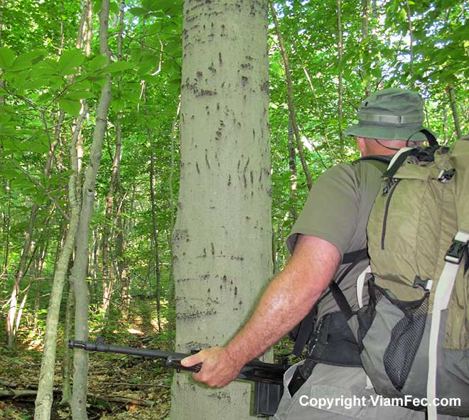
It is important to know the locations of all bridges, since mountain streams are often not fordable due to high water.For the most part this relatively modest slope on the northeast side of Mount Evans is a beautiful hardwood forest. Along the way I came upon a common sight, that of beech trees with bear claw marks scarring the bark. Bears often climb beech trees in the Fall season in order to dine on beach nuts.
Bear claw scars on the bark of a beech treeI also came upon this old logging cable. When skidding logs, loggers attach these cables to bunches of trees. When the cables break the loggers often leave the cables in the woods. Sometimes these cables are over 20-feet long and I happen upon them quite often – could come in handy for a number of purposes.
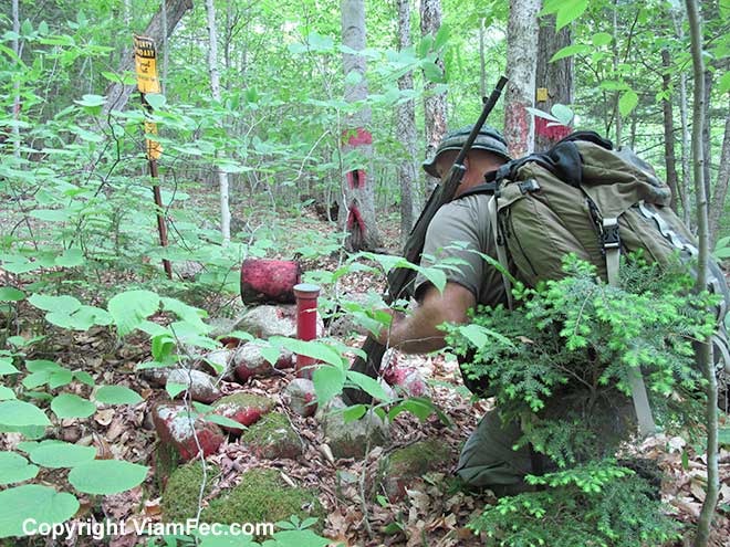
Old logging cables are found scattered throughout the Great North WoodsJust below the summit of Mount Evans is a National Forest Boundary corner. You have possibly noticed from previous Viam Fec blog posts how National Forest boundary lines, usually well blazed through the forest, can be used as valuable navigation aids. This position is labeled “2” on the map.
A National Forest boundary marker is a valuable navigational aid in the Great North Woods mountainsVery near to the summit of the mountain I came upon this cylindrical 1/4-inch thick iron piece, which appears to have been re-purposed years ago into a makeshift fire-ring, perhaps to aid in cooking. How it came to be on the summit of a mountain is possibly lost to history. Perhaps it was used in an old logging camp or hauled up here on snowmobile or ATV years ago.
Inside the cylinder is about 8-inches of forest duff – dead pine needles fallen from the nearby trees, indicating it has been sitting in the same spot for many years. Nearby are wooden boards that are nearly rotted away. This may have framed a small lean-to for camping.
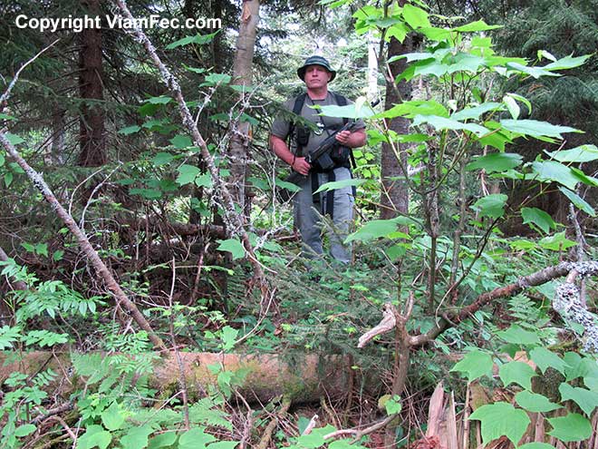
Interesting iron object near the summit of Mount EvansIn the picture above you can also see the camera tripod I carry so that I can take pictures that include myself in them. Not only am I loaded down with my basic survival needs for the mountains of the Great North Woods, I am also carrying a fair amount of camera equipment, a scout rifle, and sixty rounds of .308 ammunition.
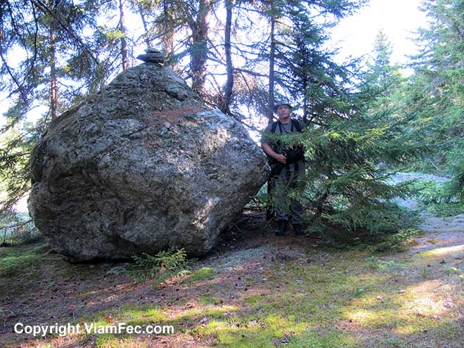
The actual highest point on Mount Evans is this large, nearly spherical boulder the last glacier dumped here some 12,000 years ago. Someone has placed two stones on the very top of this rock, making Mount Evans about a foot higher.
The highest point on Mount Evans is a boulder. This is the second Viam Fec summit.Just to the north of the Mount Evans boulder is a partial view of the wild and rugged Mahoosuc Mountain Range, said by many to be the most difficult to traverse section of the entire Appalachian Trail from Georgia to Maine. Viam Fec will be exploring the Mahoosucs, there is no doubt.
A view of the Mahoosuc Mountain Range looking North from the summit of Mount Evans
Climbing Unnamed Peak
From the summit of Mount Evans I continued the scout down into the saddle between Evans and the Unnamed Peak that was my next objective. As can be expected, the land in the saddle area is a bit swampy in places, but as the contours on the map indicate, the walking wasn’t very steep.
Looking at the topographic map, it appeared as though it would not be very steep going from the saddle to the summit of Unnamed Peak. However, the topo lines are smoothing over the reality of the land. In many places there are steep short ledges that require work-arounds.
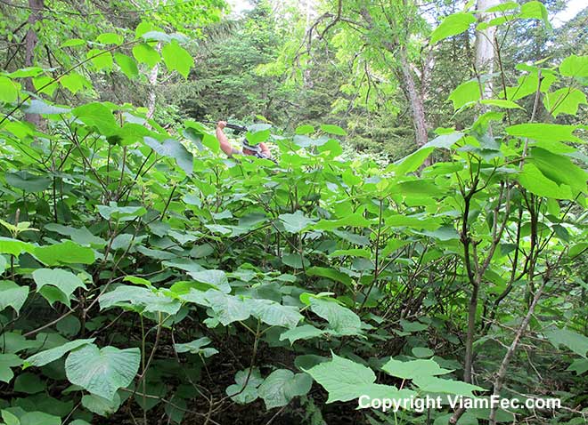
Not far from the summit of the mountain I came upon the out-of-place looking fungi growing on a log, as well as sections of hobble bush that have been heavily browsed by moose. Aptly named, hobble bushes grow into thick interlocking masses. Attempting to walk through these can hobble you every step of the way.
Swimming through a sea of hobble bush.As is often the case with mountain summits, the higher the elevation the thicker the going. Forest cover tended more toward spruce-fir. The wind picked up to nearly a gale as weather moved in (that night temperatures in the valley dropped to 36 degrees F). The picture below of me on the summit of Unnamed Peak gives an idea of what it can be like to bushwhack through the forest. As is often the case, the actual summit was a bit difficult to find, there being quite an area that could possibly be the actual summit, varying by a few feet more a less. I cast about the area seeking a likely spot and chose this one, which I captured “on film” for all posterity.
Note the thickness of the forest underbrush. Walking through miles of this can rip your clothing to shreds, not to mention harm your body in many ways.
Left out in most discussions on forest bushwhacking is the sheer mental energy and mental toughness required in order to press on through all obstacles and difficulties while still maintaining course toward the objective. Some people find they simply cannot or will not do it. This is why hiking on maintained trails is very popular while bushwhacking is not.
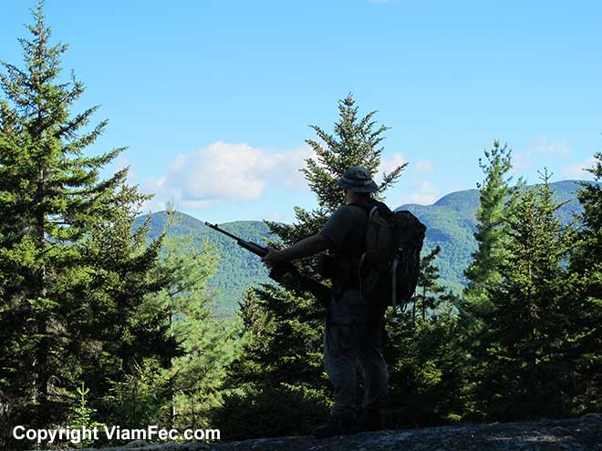
On the summit of Unnamed Peak, the third mountain Viam Fec has summited. It was very windy when I took this picture, and was thinking I might want to put on my parker as the wind-chill was getting quite low. Heavy exertion is what kept me warm. That night (June 21) there was nearly a frost in the valley so up here there probably was one.
Descent Into Josh Brook Valley
And a Cartographic Artifact
The entire day was very windy, increasingly so with elevation gain. At 2500-feet of elevation the wind was getting a bit uncomfortable, so it felt good to plunge down into the Josh Brook valley. The forest has been called “the poor mans overcoat”, which true. The lower down and deeper into the jungle the less wind and exposure to the elements.
Down, down, down I went, the going steep and entangled. Eventually cutting Josh Brook, at a point where the USGS topographic map appears to show a human structure, perhaps a cabin in the woods (labeled “4” on the map).
If you look closely at the map you will see a black square, which indicates a human made structure. Alas, it appears this is merely a cartographic artifact – an error on the map or perhaps a splotch of ink when the printing was done.
Again, and I will drill it through your heads time and time again: The Map is Not the Territory. It will show you things that are not there, and not show things that are there.
How I Lost 17% of My Water
Sliding down into the Josh Brook valley, I felt my backside getting wet. Taking off my pack, I found that one of the six water bottles I carried had its cap loosen and the contents emptied out.
I didn’t mind so much getting wet (though in winter that could be catastrophic), but I did mind losing 3/4 quart of water. Though there is usually, but not always, plenty of water to be found in this area, it is not safe to drink without boiling. I do not trust water filters or chemical means, because I know that these do not always work. I carry a hobo stove and container to cook with and boil water, but it is a time consuming process.
Because having plenty of water on-hand is so important to survival, I am going to research a more reliable means of carrying water. It is important not to use plastic, as plastics are known to leech harmful substances into food and water, which is why I only use stainless steel.
Boundary Line Navigation
I then followed Josh Brook downstream to the same waterfall I named “Boundary Falls” on a prior scout (labeled “5” on the map). It is next to these falls where a National Forest boundary line crosses the brook.
Along the way are several wonderful waterfalls, gorges, and flumes that invite exploration or even a swim. These beautiful geologic forms commonplace along the streams of the Great North Woods and mountains.
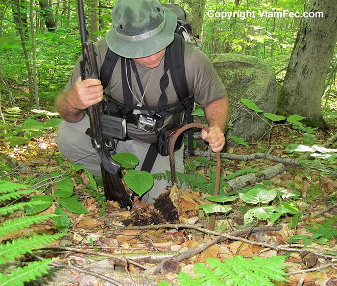
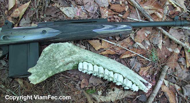
Hitting Josh Brook having bushwacked down from the summit of Unnamed Peak. This is the area where the USGS topographic map shows what appears to be a building or cabin. I found no such thing.From here my planed route of travel worked out nearly perfectly – which isn’t often the case. I followed the National Forest boundary line, blazed onto trees and painted red, from its intersection on Josh Brook to the corner point labeled 6 on the map. Here I found this moose jawbone, which was homesteaded by a colony of ants living inside.
Just downhill from here, through small apertures in the thick forest leaves, I could see tiny portions of what appeared to be a dirt road shining bright in the sunshine compared to the dark forest in which I resided. Also colorful items – perhaps the painted sides of houses, cars, tarps, etc. The road and structure(s) do not appear on the map and are apparently of relatively recent construction.
To avoid human contact I hiked uphill about 100 yards before continuing on, just to make sure. The wind rustling through trees and leaves a great aid in disguising the inevitable noise of footfalls on dry forest leaves and fallen sticks and the swishing of branches as I passed through thick undergrowth.
Moose Jawbone
The Compass is the Gold Standard of Navigation
Then I ran a compass line of about 35-degrees magnetic east hoping to intersect a National Forest boundary line near what is labeled “7” on the map. This is of course a bit risky (again, because the map is not the territory) however I knew that even should I miss the boundary line the worst that would happen is I would plunge down into the the Rattle River valley and thence an easy navigation downstream to where my truck was parked.
The distance between boundary lines is about 1/2 mile through thick forest. It was troublesome to be going “against the grain” of topography too, it being almost always easier to go straight up or straight down but not sideways along the topography while attempting to follow a compass line: there were many short climbs and descents which won’t be discernible on a map.
As it was, I did hit the boundary marker then swung around the east side of Mount Evens, hugging the contour around to the north of the summit before plunging downhill to Route 2 and my truck at the Rattle River trail head.